What you’ll take away
- Water vapor is invisible gas; the visible particles in a cloud are droplets, ice crystals or both.
- A broad shape description and a supplied particle-phase label answer different questions.
- Eight equal spherical drops can merge into one with the same liquid volume and twice the diameter under the stated model.
- Droplets can appear or evaporate while the water remains present in another state.
- Cloud-base height, altitude above mean sea level and vertical extent use different reference points.
A cloud can look fluffy without being cotton or gas
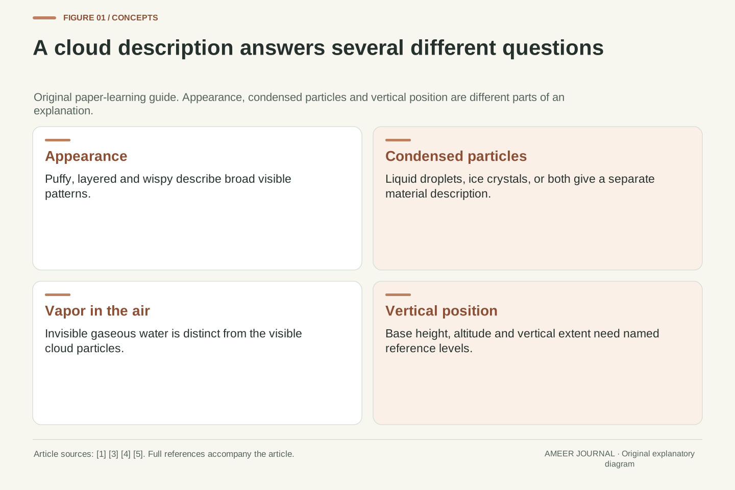
A cloud in a drawing might look like a cotton ball, a flat blanket or a few loose feathers. Those comparisons describe its appearance. They do not tell us that cotton, cloth or feathers are actually floating overhead. A visible cloud contains many tiny liquid water droplets, ice crystals, or a mixture of the two, distributed through air. NASA distinguishes these particles from water vapor, which is water in its invisible gas form. [1][5] The interesting question is how one familiar substance can produce such different-looking clouds.
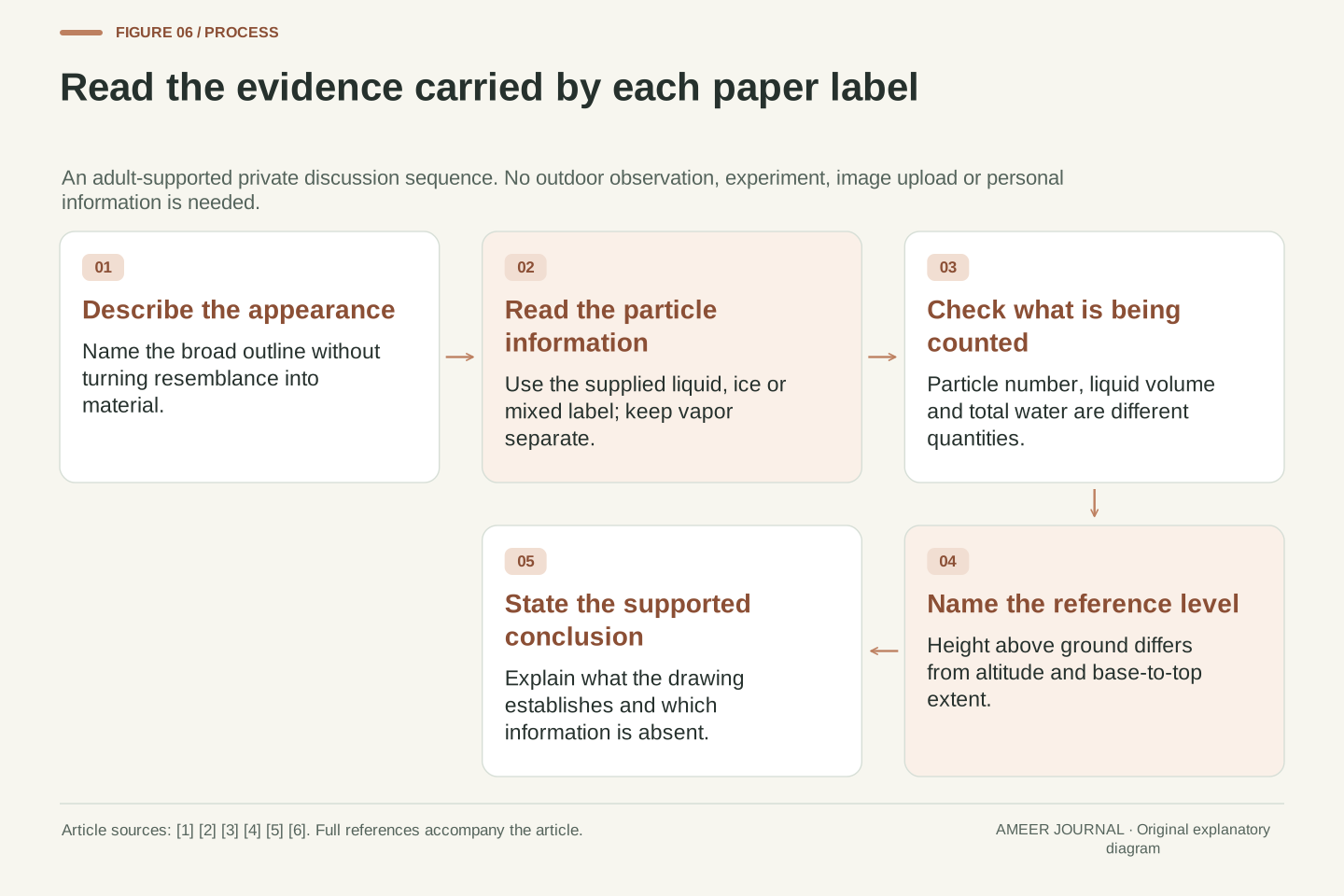
We will explore that question through original paper cards with a grown-up. Read the diagrams, draw simple outlines if you wish, and use the supplied labels. No outdoor visit, Sun watching, storm observation, camera, location or uploaded work is needed. There is no cloud-making activity with water, ice, smoke, heat, jars or tools. The cards are invented examples, not photographs or weather reports. Three questions will guide the discussion: What does the cloud look like? What kinds of water particles are named? Where are its base and top? Keeping the questions separate makes the answers much clearer.
This article distinguishes a cloud's macroscopic appearance, the phase of its condensed water, and its vertical geometry. A visible atmospheric cloud is an aggregate of droplets and/or ice particles within air, rather than a continuous block of liquid or a visible parcel of pure water vapor. NASA's cloud explanations explicitly separate invisible gaseous water from the particles associated with a visible cloud. [1][5] A familiar outline is therefore a description of structure, not a direct chemical or microphysical measurement.
The examples are adult-supported private paper reasoning. No outdoor observation, Sun viewing, physical cloud-making apparatus, camera access, location collection or submission is involved. Six stipulated cards will separate broad appearance labels from stated particle phases; a spherical-drop calculation separates particle count from liquid volume; a closed water account separates disappearance of droplets from loss of water. A final vertical-coordinate example distinguishes height above ground from altitude above mean sea level. These constructions address what a drawing can support, rather than offering a field identification key, weather forecast or measurement of real cloud properties.
Invisible water vapor and tiny liquid drops are different states
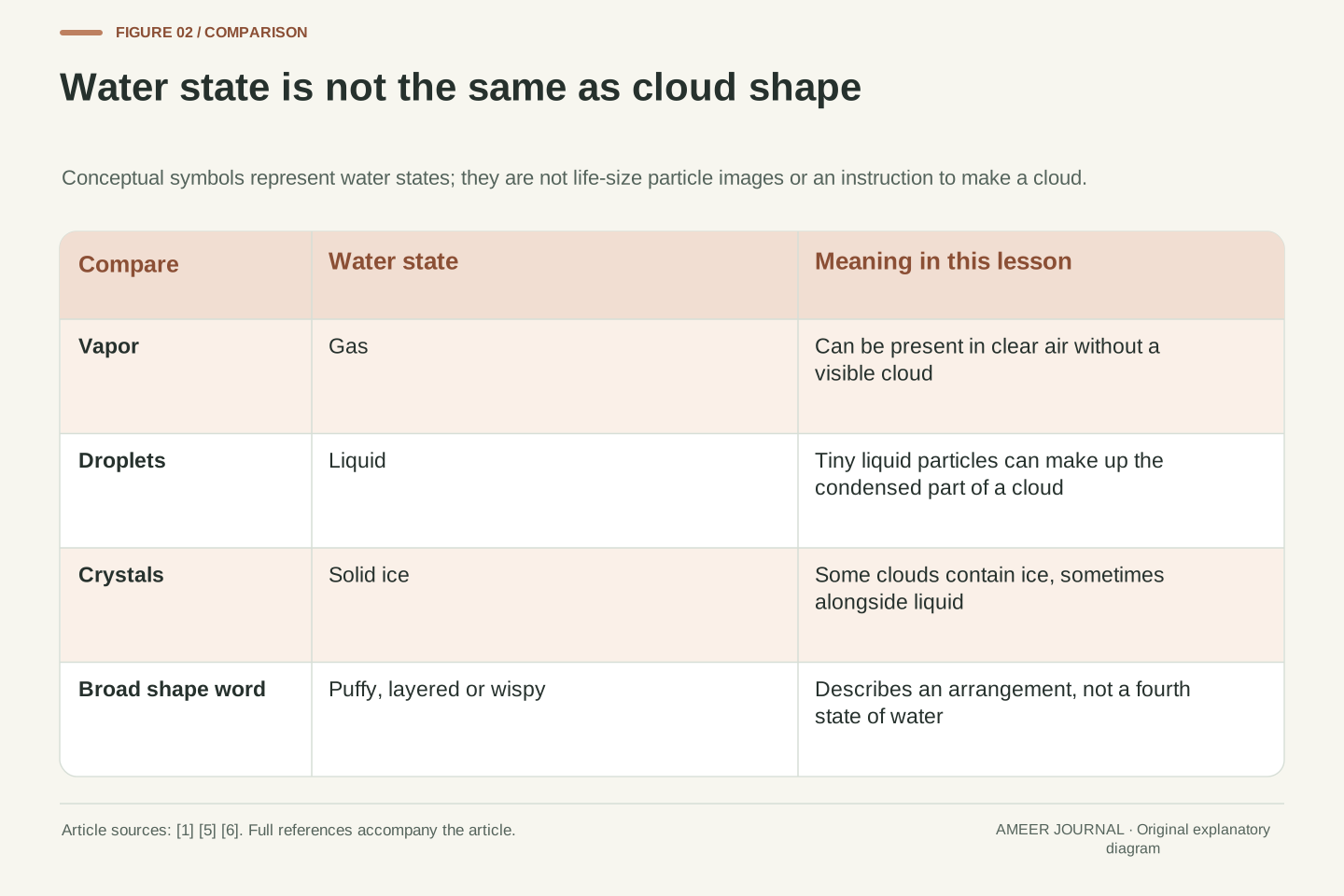
Water vapor is a gas. A tiny liquid droplet is still liquid, even when it is too small to pick out by eye. Making something small does not automatically turn it into a gas. Ice is the solid state of water. In a cloud diagram, a circle can stand for a droplet and a different symbol can stand for an ice crystal. The symbols must be explained because a large drawn circle is not a life-size picture of an actual cloud particle. [1][5]
A clear-looking patch of air can contain water vapor without containing a visible cloud. Conversely, the white or gray shape we call a cloud is not a picture of the vapor molecules themselves. It is associated with the collection of droplets or ice. Air inside a cloud can also contain vapor, so saying that the visible particles are liquid does not mean that every bit of water in the surrounding air is liquid. Try describing a card in two parts: “The visible particles are droplets; water vapor may also be present in the air.” That sentence avoids treating a cloud as one solid, sealed object.
Distinguish phase from particle size and from visibility. Gaseous H₂O dispersed among atmospheric gases is water vapor; a cloud droplet is condensed liquid containing many water molecules. An ice crystal is condensed solid water. NASA identifies the vapor as invisible and the accumulated droplets or crystals as the visible cloud. [1] The statement is about the ordinary visible appearance of atmospheric water, not a claim that vapor has no measurable interaction with electromagnetic radiation.
Our card field will be called “condensed-particle phase”, not “all water present”. A liquid-cloud card specifies liquid droplets for that field while leaving the gaseous water within the air conceptually distinct. A clear-air card can consequently have no cloud particles while still containing vapor. The gas-to-liquid transition is a physical change of state, not the creation of a different substance. Likewise, an enlarged symbol for a droplet is a representational choice, not evidence that its drawn diameter equals the real diameter or that one diagram symbol equals one observed particle. These distinctions matter when a large-scale silhouette is paired with a small explanatory inset.
A visible cloud can form when water changes state
One route to a cloud begins when moist air rises and expands as the surrounding pressure becomes lower. Expansion can cool that air. Under suitable conditions, some water vapor changes into liquid droplets on tiny particles already present in the air. NOAA describes this rising-air process and the role of condensation. [2] The change from gas to liquid is called condensation. The water was present before the cloud became visible; it was not manufactured when the white shape appeared.
There are other changes to keep separate. Evaporation turns liquid water into vapor. Freezing turns liquid into solid ice. Water vapor can also change directly into ice, a process called deposition. NASA distinguishes the direct gas-to-solid change from condensation. [1] These names describe what happens to the water, while “puffy” or “layered” describes how a cloud looks. A paper arrow should name both its starting state and its ending state. For example, an arrow from vapor to droplets can say “condensation”; an arrow from droplets back to vapor can say “evaporation”. Reversing an arrow changes the explanation, even if the drawing uses the same water symbols.
For an ascending air parcel, decreasing environmental pressure permits expansion and associated cooling. NOAA describes this adiabatic mechanism and the condensation of vapor onto suitable atmospheric particles as saturation conditions are reached. [2] The simplified account does not require treating air as a sponge with a fixed number of storage spaces. Temperature, water-vapor abundance and the relevant phase equilibrium matter; we do not derive a universal cloud-base temperature or prescribe a numerical lapse rate.
The phase-transition vocabulary is directional. Condensation is gas to liquid, evaporation is liquid to gas, freezing is liquid to solid, and deposition is gas directly to solid. The NASA resource supplies the condensation/deposition distinction. [1] Existing condensed particles can also grow or shrink while the surrounding air moves and mixes. The diagram's arrows describe selected transformations rather than a compulsory sequence through which every molecule passes. In particular, ice need not always arise by first forming a liquid droplet, and a visible droplet need not have just entered the region from somewhere else. This is a local phase explanation, not a complete model of nucleation, heat exchange or cloud dynamics.
Puffy, layered and wispy are useful starting descriptions
Cumulus clouds often have rounded, rising parts that make a puffy outline. Stratus is associated with a broad layer and a fairly uniform base. Cirrus has thin, fibrous-looking strands, and its particles are ice crystals. NOAA's cloud guide describes these forms as part of a larger classification. [3] “Puffy”, “layered” and “wispy” are useful words for our first drawings, but they are not the names of three different substances. A fluffy appearance does not mean that a cloud contains fluffy fibers.
The full system contains more than those three names. Some types combine features, and clouds can have layers, patches, rounded elements or long vertical development. A simple outline leaves many of those details out. On our cards, a shape label helps children say what they notice in the drawing; it is not enough to assign every possible real cloud to an exact type. A grown-up can ask, “Are you describing the whole cloud, or the tiny particles shown in the inset?” The answer may be “a broad layer containing droplets”. One phrase describes the arrangement, while the other describes the water within it.
The introductory appearance categories are deliberately broad. NOAA describes Cumulus through detached, vertically developed mounds or domes, Stratus through a generally uniform layer, and Cirrus through delicate filaments or fibrous patches. Its guide presents ten basic genera, not merely three shape classes. [3] The present article uses those examples to distinguish an object's large-scale morphology from the state of its constituent water, without claiming that the paper labels reproduce a full taxonomic key.
A specific identified genus carries more information than an unspecified silhouette. Cirrus, for example, is associated with ice crystals in the cited description. That does not justify labelling every sketch containing a wispy stroke as a verified Cirrus observation. Distance, perspective, missing context and the abstraction introduced by the drawing can remove distinguishing features. Our later “layered” category is broader than the genus Stratus; it must not be read as a claim that every layered cloud has the same phase. Keeping the broad descriptor and the formal name separate allows the cards to teach comparison while preserving the scientific value of a proper identification.
Cold clouds can contain liquid as well as ice
Different cloud types can contain different combinations of water particles. NASA describes low, shallow clouds with many droplets, thin upper clouds with ice, and deep clouds with both liquid and ice. [5] The World Meteorological Organization says Cumulus is mainly made of droplets but can contain ice in colder parts. [6] The useful lesson is that “cloud” is a broad word. It does not mean “all liquid everywhere” or “all ice everywhere”.
There is a detail that can surprise adults too: liquid droplets can remain liquid below the usual freezing temperature. Such water is called supercooled. [5][6] This does not mean that cold and warm are unimportant. It means that temperature alone is not a complete description of how ice forms in a cloud. On a paper card, read the stated particle label instead of inventing one from a blue background or a snowflake drawn nearby. If the label says “droplets and crystals”, both kinds are included. We will use that information directly when sorting the cards, without trying to create or handle supercooled water.
Cloud phase is not adequately represented by an unconditional rule that everything below 0 °C is frozen. The retained NASA GPM explanation identifies supercooled liquid, and the WMO Cumulus description allows ice formation within below-zero portions while discussing supercooled droplets. [5][6] We use these sources for the existence and coexistence qualifications, not for a universal freezing threshold, a particular nucleation rate or a claim that every cold cloud has the same mixture.
“Mixed phase” here means that liquid droplets and ice particles are present in the specified cloud example. It does not mean a single particle is automatically half liquid and half ice, nor does it provide a percentage by mass or number. NASA's broader composition description separates air, liquid particles and ice particles. [5] A phase label consequently needs a declared scope: an entire cloud, a particular region or a stipulated teaching card. Our cards state that scope directly and offer no measured phase retrieval from color or outline. This distinction also prevents a broad morphology label from silently becoming a quantitative water-content claim.
Sort the same cards by appearance and by their supplied particle labels
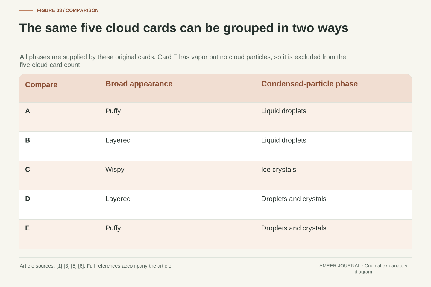
Our six original cards have these labels. A is puffy with liquid droplets. B is layered with liquid droplets. C is wispy with ice crystals. D is layered with droplets and crystals. E is puffy with droplets and crystals. F is clear air containing water vapor but no cloud particles. All particle descriptions are information supplied by the cards. You are not being asked to discover hidden ice or droplets from an outline. F stays outside the visible-cloud group because its label supplies no cloud particles.
Sort the five cloud cards by appearance. A and E are puffy, B and D are layered, and C is wispy: two, two and one. Now sort those same five by condensed-particle phase. A and B have liquid only, C has ice only, and D and E have both: again two, one and two, but the groups contain different cards. A and B show different shapes with the same supplied phase. B and D share a broad shape word but have different supplied phases. Each sorting rule answers its own question. Neither replaces the information on the other label.
Define the five visible-cloud cards explicitly: A=(puffy, liquid), B=(layered, liquid), C=(wispy, ice), D=(layered, mixed), E=(puffy, mixed). Card F denotes clear air with vapor but no condensed cloud particles and is excluded from both cloud-card partitions. The phase assignments are stipulated educational inputs, not inferences from rendered outlines, measured samples or claims about every member of a named genus.
The appearance partition is {A,E}, {B,D}, {C}, with counts 2,2,1. The particle-phase partition is {A,B}, {C}, {D,E}, with counts 2,1,2. Both sum to five, but their membership differs. In this declared set, A and B provide different morphology labels with the same phase; B and D provide the same broad morphology label with different phases. This is a small classification exercise demonstrating that two attributes are not interchangeable. It does not establish statistical independence in nature or imply that formal cloud identification contains no information about phase. Retaining both supplied labels is more informative than collapsing the cards into one ambiguous word such as “type”.
Fewer drops can contain the same amount of liquid water
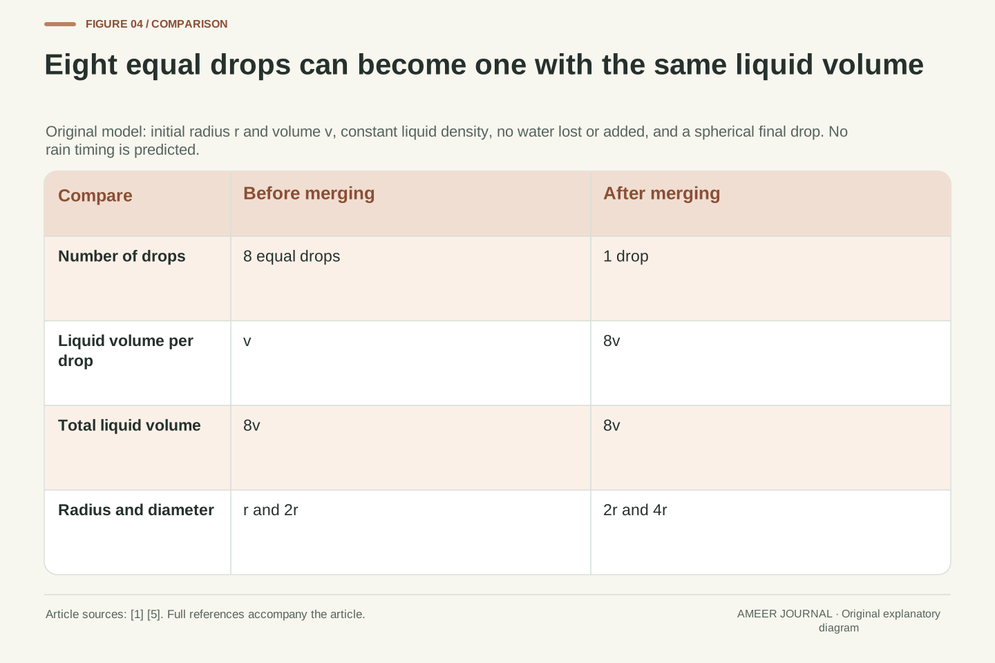
The number of droplets is another different question. Imagine eight equal spherical liquid drops in an original paper model. Each contains one small drop's worth of water. Suppose they join into one spherical drop, with none of the water lost or added. The new drop contains eight small drops' worth, although the number of drops has fallen from eight to one. Counting the drawings alone would miss the change in each drop's size.
For these ideal spheres, the new drop's width is twice the old width, not eight times. A sphere grows in three dimensions. Doubling its width multiplies its volume by two times two times two, which is eight. A grown-up can connect that result to the Technical equation while a child focuses on the water account: eight portions before, eight after. This model does not say how quickly real cloud drops join or when rain will begin. It shows why “more droplets” and “more liquid water” are different statements unless the sizes are also known. The circles on paper are symbols for spheres, not flat puddles.
Let each of eight identical spherical liquid droplets have radius r and volume v=4πr³/3. Assume constant liquid density, no evaporation or other transfer of water, and one spherical merged drop of radius R. Conservation of liquid volume gives 4πR³/3=8v=8·4πr³/3. Hence R³=8r³ and R=2r. Diameter also doubles, while particle count decreases by a factor of eight.
This original geometric construction is conditional on the stated equal-size, equal-phase and spherical assumptions. It is not a simulation of collision efficiency, deformation during merging, cloud evolution or precipitation. Eight “small-drop portions” are a volume account, not eight cubic units inferred from an arbitrary drawing scale. A two-dimensional cross-section with twice the diameter would have four times the area, while the corresponding three-dimensional sphere has eight times the volume. The distinction explains why a particle count, an apparent drawn area and total condensed-water volume cannot be substituted for one another. Real particle-size distributions require additional information; our paper model supplies only the variables used in this exact comparison.
A cloud outline can change while the water remains in the air
A cloud is not a fixed fabric shape being dragged intact across the page. Air moves, droplets can form, and droplets can evaporate. NOAA explains that condensation and evaporation happen continually as air rises and mixes, helping clouds grow, fade and change shape. [2] If a white part disappears, that does not by itself tell us that all its water left the atmosphere. Some liquid water may have become invisible vapor.
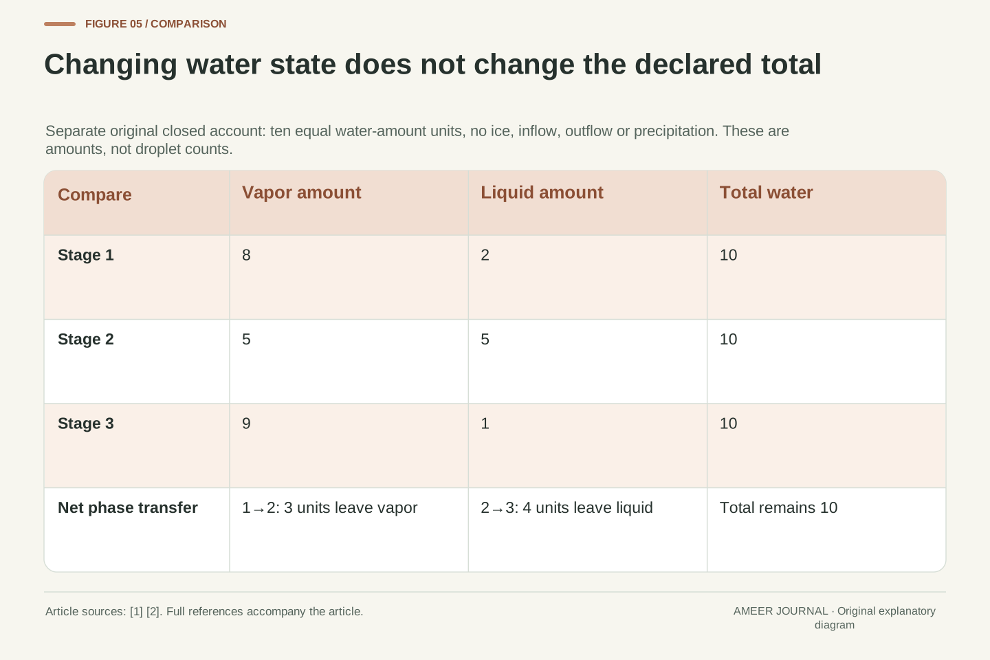
Use a separate paper account containing ten equal amounts of water, with no water entering or leaving. At the first stage, eight amounts are vapor and two are liquid. At the second, five are vapor and five are liquid: three amounts have changed from vapor to liquid. At the third, nine are vapor and one is liquid: four amounts have changed from liquid to vapor since the second stage. Every stage still contains ten amounts. These are amounts of water, not counts of droplets. The account makes one point clearly: changing the visible condensed part does not require creating or destroying the total water.
A cloud boundary marks a region's condensed-particle conditions rather than the surface of a permanent solid body. NOAA describes simultaneous condensation and evaporation during motion and entrainment, with the balance affecting whether cloud grows or dissipates. [2] An evolving outline therefore need not track an invariant set of droplets or water molecules. This does not deny transport by wind; it separates transport of material from changes in the visible pattern caused by local phase processes.
In an independent closed-account example, use arbitrary equal water-amount units and exclude ice, inflow, outflow and precipitation. The vapor/liquid pairs are (8,2), (5,5) and (9,1). Each totals ten. The first transition transfers a net three units from vapor to liquid; the second transfers a net four units from liquid to vapor. The account does not specify temperature, elapsed time, particle count or the energy exchanges needed to realize a particular trajectory. It is a conservation check, not a weather simulation. Equal total water across the stages is compatible with different condensed amounts, so visual disappearance alone cannot establish that water has ceased to be present.
A low cloud base and a tall cloud can belong together
Cloud descriptions also use position. A cloud can begin relatively low and extend a long way upward. The World Meteorological Organization distinguishes the base, the top and the vertical distance between them. Its cloud levels overlap, and their usual boundaries vary with latitude. [4] That is why “low” should not be read as a promise that every part of a cloud stays close to the ground.
Here is an invented height card. Ground is five hundred meters above mean sea level. The cloud base is at an altitude of fifteen hundred meters, and its top is at thirty-five hundred meters. The base is one thousand meters above that ground: fifteen hundred minus five hundred. The cloud itself extends two thousand meters vertically: thirty-five hundred minus fifteen hundred. These are different distances with different starting points. The same cloud also has a top three thousand meters above the ground. We are reading supplied numbers, not estimating heights from a picture. A useful label always says which reference level the distance starts from.
WMO defines height relative to the observing point on Earth's surface, altitude relative to mean sea level, and vertical extent from cloud base to cloud top. Its high, middle and low levels overlap and vary with latitude; clouds with low bases can extend into higher levels. [4] These are separate geometric descriptors, so neither a base-level label nor a simplified apparent shape determines the full vertical span.
For the original coordinate card, set ground altitude z_g=500 m, base altitude z_b=1500 m and top altitude z_t=3500 m, all relative to mean sea level. Base height is z_b−z_g=1000 m; vertical extent is z_t−z_b=2000 m; top height is z_t−z_g=3000 m. The base height plus the cloud’s vertical extent equals the top height: 1000 m + 2000 m = 3000 m. The same number cannot stand for altitude, height and extent without its reference definition. No observational uncertainty, terrain variation or retrieval method is supplied because the coordinates are stipulated. The example teaches a reporting convention rather than assigning a formal genus from one altitude or suggesting that a child can measure cloud height from a sketch.
Explain the drawing without claiming more than its labels show
Finish with four questions for a grown-up and child to discuss. Is the clear-air card necessarily free of water? No: it says vapor is present. Do all layered cards have the same supplied particle phase? No: B has droplets, while D has droplets and crystals. Does combining eight equal drops into one mean seven portions of water vanished? No: the model keeps all eight portions. Does a base one thousand meters above ground tell us the cloud is only one thousand meters thick? No: its base height and vertical extent are different quantities.
You can describe an imaginary animal in a cloud outline and still keep the science clear. “It looks like a rabbit” describes a resemblance. “Its card says liquid droplets” describes supplied particle information. “Its base is this far above ground” describes a distance. None of those statements has to replace the others. Keep the page private; there is no score, photograph or report to send. The useful achievement is a fuller explanation: clouds have shapes, but their visible particles, changing water states and positions need their own descriptions. A careful sentence tells the reader which of those questions it has actually answered.
The closing questions test four distinct errors: treating clear air as water-free, equating a broad morphology class with a unique phase, confusing particle count with conserved liquid volume, and using base height as though it were vertical extent. Each answer follows from a declared label or calculation. None requires claiming that the supplied card set is a representative atmospheric sample.
A useful final description preserves these layers of information. Appearance can support a comparison or contribute to cloud identification; particle constitution states whether condensed water is liquid, ice or mixed; phase processes explain how visible structure can change; geometric references locate the base and top. NASA and NOAA provide the formation and constitution context, while WMO makes the height terminology explicit. [1][2][4][5][6] Our paper constructions add exact checks on the reasoning without implying a field observation, phase-retrieval instrument or forecast. The child can use the Easy labels, and an adult can extend the discussion with the Technical equations. Both modes reach the same conclusion: an outline is one informative feature of a cloud, not a complete account of its material and behavior.
Sources & further reading
Explore the references behind this guide. External pages may change after our review.
- How Do Clouds Form? - NASA ScienceNASA Science / NASA JPL-Caltech · Accessed 7 Nov 2026
- How Clouds Form | National Oceanic and Atmospheric AdministrationNOAA / National Weather Service JetStream · Accessed 7 Nov 2026
- Ten Basic Clouds | National Oceanic and Atmospheric AdministrationNOAA / National Weather Service JetStream · Accessed 7 Nov 2026
- Definitions of clouds | International Cloud AtlasWorld Meteorological Organization / International Cloud Atlas · Accessed 7 Nov 2026
- What are clouds made of? Are they more likely to form in polluted air or in pristine air? | NASA Global Precipitation Measurement MissionNASA / Global Precipitation Measurement · Accessed 7 Nov 2026
- Physical constitution | International Cloud AtlasWorld Meteorological Organization / International Cloud Atlas · Accessed 7 Nov 2026
Article updated 7 Nov 2026.